Goals of the lab:
1) Delineate a study area from a larger satellite image.
2) Demonstrate how spatial resolution of images can be optimized for visual interpretation purposes.
3) Introduce some radiometric enhancement techniques in optical images.
4) Linking a satellite image to Google Earth
This was was our introduction to various reampling methods. All of our data was found on our school server.
The first part of this lab was about creating an area of interest. This is also known as Image subsetting, and there are two general ways to do this. The first way makes a square or rectangular study area with the use of the tool Inquire Box. This is a very simple way to this but is limited by the fact that it can only create a square or rectangular study area. The second way is to delineate and Area of Interest using a shapefile or headsup digitization. This way ends up being the more widely used as it's area of study can be any shape.
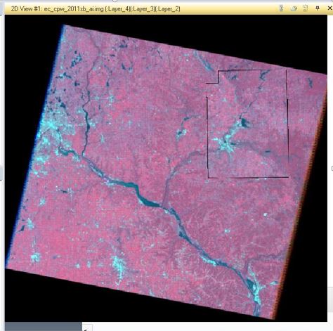
To start an image was uploaded into Erdas, the focus on this piture was on the Eau Claire and Chippewa Valley Counties. Then under Raster tools the Inquire Box tool is used. This tool gives you a white box with which you can click and drag to create your square or rectangular area of study. A Inquire Box viewer will appear when this tool is used, and will show a few things like the units the box is using as well as the option to change to color off the box, it is originally white and may be hard to see on certian images. There are also buttons on the bottom with Apply, Fit to AOI, Close and Help. After the area is set, Apply will need to be clicked.
Back under Raster tools, the next step is to go under the Subset & Chip dropdown menu and use Create Subset Image. This process automatically puts the image on the image viewer. This image needs to then be saved in a seperate folder, which can be chosen under the Output File slot in the Subset interface. From Inquire Box will also need to be clicked, before hitting Ok and having the Subset interface run. After the process is complete you will need to hit dismiss and then bring in the image just created. This is the process to use the Inquire Box.
Using Area of Interest to create a subset starts the same as with the Inquire Box, the picture you want to subset needs to be brought into Erdas. The next step is to add in the shapefile, but the Select Layer To Add interface will need to be changed from .img to .shp in order to see it. To do this click the dropdown selection uder Files of Types and select .shp. Select the shapefile needed and add to the viewer. Then shift click the two counties, this should change their color, and under the Home tools use Paste From Selected Object. If done correctly it should show dotted lines around the selected areas. To save this select AOI Layer As under Save As. Back under Raster select Subset & Chip, in this interface is where the output folder is selected and it where the AOI button that needs to be clicked is. After that all the needs to be done is adding the image back to the viewer.
1) Delineate a study area from a larger satellite image.
2) Demonstrate how spatial resolution of images can be optimized for visual interpretation purposes.
3) Introduce some radiometric enhancement techniques in optical images.
4) Linking a satellite image to Google Earth
This was was our introduction to various reampling methods. All of our data was found on our school server.
The first part of this lab was about creating an area of interest. This is also known as Image subsetting, and there are two general ways to do this. The first way makes a square or rectangular study area with the use of the tool Inquire Box. This is a very simple way to this but is limited by the fact that it can only create a square or rectangular study area. The second way is to delineate and Area of Interest using a shapefile or headsup digitization. This way ends up being the more widely used as it's area of study can be any shape.
To start an image was uploaded into Erdas, the focus on this piture was on the Eau Claire and Chippewa Valley Counties. Then under Raster tools the Inquire Box tool is used. This tool gives you a white box with which you can click and drag to create your square or rectangular area of study. A Inquire Box viewer will appear when this tool is used, and will show a few things like the units the box is using as well as the option to change to color off the box, it is originally white and may be hard to see on certian images. There are also buttons on the bottom with Apply, Fit to AOI, Close and Help. After the area is set, Apply will need to be clicked.
Back under Raster tools, the next step is to go under the Subset & Chip dropdown menu and use Create Subset Image. This process automatically puts the image on the image viewer. This image needs to then be saved in a seperate folder, which can be chosen under the Output File slot in the Subset interface. From Inquire Box will also need to be clicked, before hitting Ok and having the Subset interface run. After the process is complete you will need to hit dismiss and then bring in the image just created. This is the process to use the Inquire Box.
Using Area of Interest to create a subset starts the same as with the Inquire Box, the picture you want to subset needs to be brought into Erdas. The next step is to add in the shapefile, but the Select Layer To Add interface will need to be changed from .img to .shp in order to see it. To do this click the dropdown selection uder Files of Types and select .shp. Select the shapefile needed and add to the viewer. Then shift click the two counties, this should change their color, and under the Home tools use Paste From Selected Object. If done correctly it should show dotted lines around the selected areas. To save this select AOI Layer As under Save As. Back under Raster select Subset & Chip, in this interface is where the output folder is selected and it where the AOI button that needs to be clicked is. After that all the needs to be done is adding the image back to the viewer.
The second part of the lab was Image Fusion, the plan being to create a higher quality image by combining two images.
Firstly in Erdas the image that is going to be enhanced should be added, then add a second viewer and add the image that is going to be used to enhance the first image. After this is set up click in the Raster tool section, Pansharpen then Resolution Merge. This will bring up the Resolution Merge window, which has lots of options. The first option to deal with is the High Resolution Input File, in which the high resolution image, which is the image on the right in the viewer, is added. Then the image to be fixed needs to be added using the Multispectral Input File. The Output File option is where the new image will be saved. Under Method there will be three options, in this case Multiplicative is one needed. Similarily Resampling Techniques has some options as well and Nearest Neighbor is the one needed. After that hit Ok and it will run the merge. When it is done, hit dismiss and bring in the new image to the viewer, by taking out the old panchromatic one. The images can be compared by linking the views. This is done under the Home view, Link Views then Sync views.
Part Three: Using Radiometric Enhancement techniques to enhance image spectral and radiometic quality.
Begin by bringing the image that will be worked with into Erdas. Then under Raster click Radiometric then Haze Reduction. Under Input File, input the image being used, and create and output file. Default parameters are good, so click OK run the model and Dismiss. Then all that's needed is to bring the new image into the viewer.
Part 4: Linking image viewer to Google Earth.
Unfortunately I was unable to do this part owing to the fact that the Google Earth option didn't show up in Erdas for me. It should be in the tools and it wasn't.
Part 5: Resampling
After adding the needed image to Erdas, the pixel size is needed which can be found in the Image Metadata. Then go under Raster and click Spatial, then Resample Pixel Size. Doing this will open the Resample menu from which the selected image can be put in under Input File. However in the output cell change cell size from 30x30 to 20x20 meters in both the XCell and YCell then hit OK. Open said image in the viewer. This processes was repeated with a second image, but the resampling method was changed to Bilinear Interpolation, and again the pixel size was changed to 20x20meters.
After adding the needed image to Erdas, the pixel size is needed which can be found in the Image Metadata. Then go under Raster and click Spatial, then Resample Pixel Size. Doing this will open the Resample menu from which the selected image can be put in under Input File. However in the output cell change cell size from 30x30 to 20x20 meters in both the XCell and YCell then hit OK. Open said image in the viewer. This processes was repeated with a second image, but the resampling method was changed to Bilinear Interpolation, and again the pixel size was changed to 20x20meters.
 RSS Feed