Goal: An Introduction to an image preprocessing exercise called geometric correction.
Use a USGS 7.5 minute DRG image of the Chicago Metropolitan Statistical Area to correct and image from Landsat TM image of the same area. To do this GCPS (ground control points) will need to be placed on the USGS image and then the DRG image to correct it.
Use a corrected image from Landsat TM to correct a geometrically distorted image of the same area.
Part 1: Image-to-map Rectification
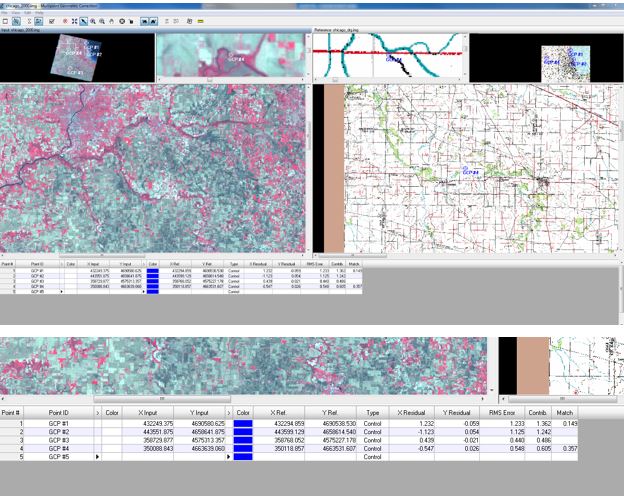
Enter the USGS image into Erdas in one viewer and the DRG image in another. The image to be rectified should be in the second viewer. Under the Multispectral tab choose the Control Points tool. The Set Geometric Model window should now be open and in the Select Geometric Model dialog choose Polynomial and hit OK. This will open two tools, the Multipoint Geometric Correction tool and the GCP Tool Reference Setup. Firstly deal with the Multipoint tool, this will help guide in the taking of GCPS and help complete the process of geometric correction. The GCP tool is how to collect the reference points. There are a few ways in which these can be obtained.
In the GCP Tool Reference Setup accept the default Image Layer (New Viewer) and click OK. Next add the reference image. This should open a new window, Reference Map Information, and click OK. This will open the window Polynomial Model Properties (no file) window. The status bar should read "model has no solution". This means that there is no polynomial telling it what to do. Once enough GCPs are collected for the transformation coefficient model selected it will change. Accept the default parameters and click close. Maximize the Multipoint Geometric Correction window, it will be easier to collect GCPs this way.
On the left should be the input image while the reference image is in the right pane. Each side of this window will have 3 different panes the top left on both sides will have the entire image while the top left will have a zoomed in image. At this point it's time to start adding GCPS, but to start the automatic GCPS need to be deleted. Shift and highlight the rows of GCPs until are all highlighted and click Delete Selection.
This lab had us doing a 1st order polynomial so 3 GCPs were needed, though 4 were done. To add the points click Create GCP tool icon to activate the tool, your mouse will become crosshairs & where you click will become the GCP. This lab had specific places for the placement of the GCPs so ours was supposed to mimic the example. The color of the points can be changed to make them easier to see on different colored images. The model solution should now read "Model Solution is Current". But this does not mean they are placed well, to check this you need to check the Root Mean Square error (RMS). This is in the Multipoint Geometric Correction window on the right side. The ideal in below .5 but for this part of the lab the goal was under 2.0. The next step was to go and reposition the GCPs until all of the RMS numbers were under 2.0.
Use a USGS 7.5 minute DRG image of the Chicago Metropolitan Statistical Area to correct and image from Landsat TM image of the same area. To do this GCPS (ground control points) will need to be placed on the USGS image and then the DRG image to correct it.
Use a corrected image from Landsat TM to correct a geometrically distorted image of the same area.
Part 1: Image-to-map Rectification
Enter the USGS image into Erdas in one viewer and the DRG image in another. The image to be rectified should be in the second viewer. Under the Multispectral tab choose the Control Points tool. The Set Geometric Model window should now be open and in the Select Geometric Model dialog choose Polynomial and hit OK. This will open two tools, the Multipoint Geometric Correction tool and the GCP Tool Reference Setup. Firstly deal with the Multipoint tool, this will help guide in the taking of GCPS and help complete the process of geometric correction. The GCP tool is how to collect the reference points. There are a few ways in which these can be obtained.
In the GCP Tool Reference Setup accept the default Image Layer (New Viewer) and click OK. Next add the reference image. This should open a new window, Reference Map Information, and click OK. This will open the window Polynomial Model Properties (no file) window. The status bar should read "model has no solution". This means that there is no polynomial telling it what to do. Once enough GCPs are collected for the transformation coefficient model selected it will change. Accept the default parameters and click close. Maximize the Multipoint Geometric Correction window, it will be easier to collect GCPs this way.
On the left should be the input image while the reference image is in the right pane. Each side of this window will have 3 different panes the top left on both sides will have the entire image while the top left will have a zoomed in image. At this point it's time to start adding GCPS, but to start the automatic GCPS need to be deleted. Shift and highlight the rows of GCPs until are all highlighted and click Delete Selection.
This lab had us doing a 1st order polynomial so 3 GCPs were needed, though 4 were done. To add the points click Create GCP tool icon to activate the tool, your mouse will become crosshairs & where you click will become the GCP. This lab had specific places for the placement of the GCPs so ours was supposed to mimic the example. The color of the points can be changed to make them easier to see on different colored images. The model solution should now read "Model Solution is Current". But this does not mean they are placed well, to check this you need to check the Root Mean Square error (RMS). This is in the Multipoint Geometric Correction window on the right side. The ideal in below .5 but for this part of the lab the goal was under 2.0. The next step was to go and reposition the GCPs until all of the RMS numbers were under 2.0.
After this click Display Resample Image Dialog to save the image. All parameters are fine at default so click OK, then Dismiss at the end of the model run. No need to save the Current Geometric Model and No on the Verify Save on Close and another No.
"What function(s) did the image Chicago_drg.img performed in the geometric correction
process?" -- The GCPs corrected the second image by spatial interpolation.
"Name and describe the type of interpolation that is being performed by the resampling dialog
window you just clicked above." -- Spatial Interpolation
"Why did you spread the four points you collected across the images and did not only
concentrate them on one or two areas of the images?" -- Because if you only put them in one area only that area would be corrected so by spreading them out the entire image gets corrected.
"Briefly explain the first order polynomial equation/model used in the above geometric
correction exercise." -- First order polynomial are linear and fits a plain to the data.
"What is the minimum number of ground control points needed to perform a 1st order
polynomial transformation?" -- 3
Part 2: Image to Image registration
Erdas opened with the image with distortion then overlay the second image. To better see the extent of the distortion under the Transformation Tab choose Swipe. This will allow you to move the top picture across the bottom one to see the difference. If this is done, after clear the viewer and bring the images back into the viewer with the distorted image on the right and the clear image on the left. Now to add GCPs to correct the image. Back under Multispectral is the Control Points tool.
Under Select Geometric Model select Polynomial and click OK in the Collect Reference Points From.
"What type of map coordinate system is the reference image in?" -- UTM Zone 29 WGS 84
Click on the Polynomial Model Properties and change the Polynomial Order to 3 and click close.
"What is the minimum GCPs you need to collect to perform a 3rd order polynomial
transformation?" -- 10
Then to add the GCPs, with the Create GCP tool. We had another photo for reference of where we should put the points so we followed that. This time 12 GCPs were added.
"Why is the Multipoint Geometric Correction interface reporting that model has no solution
even though you have collected up to 9 points but for part 1 above, once you had 3 points your
model reported that “Model solution is current”?" -- Until you add the 10th GCP the model it will tell you "model has no solution" because it's under a 3rd Order Polynomial so once you hit the 10th one it will change to "model solution is current".
Then the GCPs this time had to have a RMS error of less than 1, so that took a lot of tweaking and subtle moving and some time. Then go through and save the same way as the other one. Then open a new viewer with the image just created and the distorted one. Then use the swipe feature again to see how big the difference is.
"How geometrically correct is your rectified image? In other words, how spatially accurate is
it in relation to the reference image you used?" -- The new picture is much more spatially and geometrically correct.
"Why was a bilinear interpolation resampling selected above instead of nearest neighbor as
executed in part 1?" -- Because this method of resampling corrects more.
 RSS Feed