For our final project we had to create own lab with our own question, and way to answer using different ArcMap tools. My question was where to place a cabin in Barron County WI. My criteria were:
1) The cabin needs to be within a 1/2 mile of water.
2) The Hydrocode needed to equal Lake/Pond, Intermittent or Lake/Pond, Perennial
3) The spot needed to be at least 3 miles away from a point of fire.
4) It needed to be placed in a census tract with more than 4,000 people and less than 4,500 people.
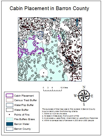
This was a fun and frustrating assignment. It was a lot of work but I am proud of the results.
The first thing I did was download the correct data. I used data from the two school databases, one for WI and one for the US. So the first thing I needed to do was use the WI county layer to make a new layer for the outline of Barron County. After that I needed to clip all the other layers so all that was left was what was in Barron County. This took a long time because two of the layers were for all of the US. After that I needed to create a 3 mile buffer around the fire occurence points. Using that buffer I then erased the area within creating the transparent blue layer.
After that I queryed the water types using HYDROCODE = Lake/Pond, Intermittent or HYDROCODE = Lake/Pond, Perennial to create the pinkish water layer. Using the new layer I buffered a half mile around the correct water types.
I queryed the census tracts next using the query POP10 >= 4000 AND POP10 <=45000.
I then did a couple of half intersect and you can see those in the map below. The blue line was the intersect between the water buffer and being in the correct census tract. The orangeish line around the purple is the census tract with the firebuffer. I then tried to interset the two of those and it didn't work so I went back and just did it all in one intersect. The result of this intersect is the thick purple lines.
The result is where you would put a cabin according to my criteria.
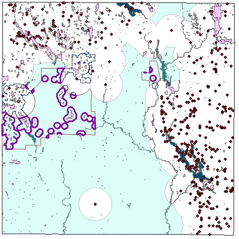
The layers that don't appear on the map above are these:
There are two water layers, one is blue and that is all of the water bodies and the pinkish ones are the ones that have the correct hydrocode.
There are two water layers, one is blue and that is all of the water bodies and the pinkish ones are the ones that have the correct hydrocode.
 RSS Feed